Urban Meteorology: UrbanNet

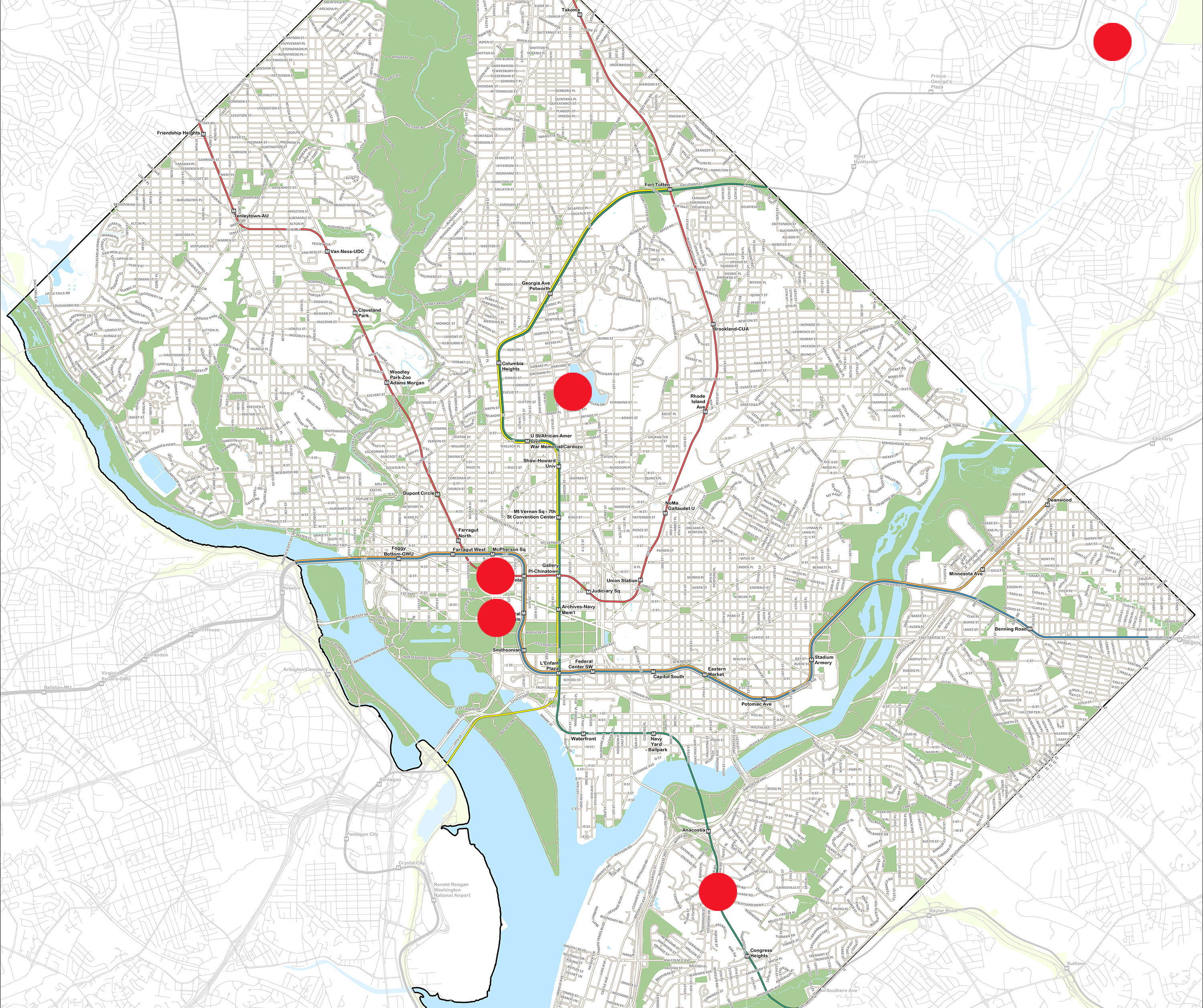
UrbanNet is a research program established in February 2023 by ARL to support urban climate and greenhouse gas (GHG) monitoring in and around the Washington D.C. area, with the idea that it could also be implemented in other urban areas. To better characterize the urban environment, multiple UrbanNet rooftop stations are being established in the Washington D.C. metro area. As of late 2024 there are five sites in the network, one at Howard University, two at the U.S. Department of Commerce Herbert C. Hoover Building (HCHB), one at D.C.’s Homeland Security and Emergency Management Agency (HSEMA) and one at the NOAA Center for Weather and Climate Prediction (NCWCP) in College Park, MD. Having two systems co-located at the north and south ends of the Hoover building assists in the intercomparison of sensor accuracy.

Current UrbanNet sites are marked on the interactive map. Clicking each marked location will bring up a new tab with the dashboard for that site.

Urban Meteorological Observations

UrbanNet is the successor to DCNet. It uses sensors to provide continuous high-resolution meteorological measurements of air temperature, relative humidity, wind speed and direction, atmospheric pressure, incoming and outgoing longwave and shortwave radiation, infrared temperature, precipitation, wet bulb globe temperature (for measuring heat stress), turbulence and heat flux. As improved measurements of urban heat stress and precipitation trends are crucial for an array of planning activities, UrbanNet also employs precipitation gauges using both a tipping bucket and a higher precision weighing gauge, the same one used in the U.S. Climate Reference Network. 

New instruments include black globe thermometers to assist with monitoring urban heat stress, atmospheric pressure, incoming and outgoing short- and long-wave radiation and infrared temperature. Ceilometers and 3D lidars that take urban boundary layer measurements and monitoring cameras will be deployed in future phases to assist with both quality assurance of data and monitoring any special weather conditions. Current sites have co-located Doppler LiDARs in collaboration with NOAA/CSL and Howard University. These provide vertical profiles of wind components, wind direction and turbulence information in the lower part of the atmosphere, in addition to boundary layer height.  

These high resolution meteorological and boundary layer measurements are crucial for advancing our understanding of urban surface-atmospheric exchange processes, urban boundary layer characteristics, impact of the urban heat island effect, turbulence and winds, the effects of climate change in urban areas and the associated stresses (e.g., heat and extreme precipitation). In addition, these observations are needed to evaluate and improve numerical modeling for the urban environment, to assimilate observations into models, conduct future urban heat studies and to provide the driving meteorological observations for atmospheric transport and dispersion models; thereby improving the prediction of material dispersion in the urban environment.

UrbanNet will eventually be expanded to at least five additional sites around the Washington D.C. metro area. The renaming of DCNet to UrbanNet was meant to allow more flexibility to possibly expand the program to other urban areas, however that is dependent on the availability of funding and so at this point we have no plans to expand the network beyond the DC metro area.

Urban Emissions of Greenhouse Gases

Urban emissions of greenhouse gases (GHG) represent a large portion of anthropogenic GHG contributions to the global carbon budget. As the global population increasingly lives in cities, the proportion of anthropogenic emissions in urban areas relative to rural regions is increasing. Systematic biases in urban emissions can significantly alter regional and global emissions and climate projections. In the next stage of instrumentation, UrbanNet is incorporating measurements of both GHG and fluxes to better quantify urban GHG emissions, assess biogenic and anthropogenic contributions and support urban GHG monitoring and modeling efforts.

Together, UrbanNet observations will play a key role in evaluating and improving emissions inventories by utilizing observations of GHG and an inverse modeling system using the HYSPLIT model. This is an important component of the Urban GHG Emissions Measurement and Monitoring System (Urban-GEMMS) to measure and model U.S. emissions of urban GHG. This system is being developed by ARL, in collaboration with other NOAA labs and NIST, to support the National Strategy to Advance an Integrated U.S. Greenhouse Gas Measurement, Monitoring, and Information System.

Results from this project will provide an improved understanding of urban GHG emissions, their transport, dispersion and uncertainty that can be applied to ecological modeling. They will also improve emissions inventories for climate models. ARL will share this policy-relevant science information, which federal and state regulatory agencies can use to mitigate GHG emissions and implement strategies to control air pollution; and ultimately provide an improved understanding of air pollutants and sources of GHGs in the Mid-Atlantic region.

UrbanNet Site Dashboards

NOAA Center for Weather and Climate Prediction (NWCP) UrbanNet Dashboard button. click for live data from this location
Howard University UrbanNet Dashboard button. click for live data from this location
H.C.H.B. North UrbanNet Dashboard button. click for live data from this location
H.C.H.B. South UrbanNet Dashboard button. click for live data from this location
D.C.'s Homeland Security and Emergency Management Agency UrbanNet site. Click for the live data stream.
UrbanNet tower on the south end of the Department of Commerce Building.
Sensors for measuring (left to right on the top): incoming and outgoing short- and long-wave radiation, infrared temperature, solar radiation, heat stress and (underneath) precipitation on the Department of Commerce south tower.
Scene on a flat top roof, Washington Monument in background. UrbanNet tower stands on the roof behind the LiDAR instrument in the foreground.
HALO Photonics wind LiDAR (NOAA/CSL).