Forest Micrometeorology and Carbon Fluxes: Chestnut Ridge

Forests cover a little more than 30% of the Earth’s surface, but store around 45% of total terrestrial carbon. Roughly one-third of the total carbon dioxide emitted each year from fossil fuel combustion or land use changes is taken up by the world’s forests by photosynthesis. Although there is evidence that forests have adapted to rising atmospheric carbon dioxide (CO2) concentrations, scientists do not know whether the world’s forests can continue to take up carbon at similar rates indefinitely as CO2 continues to rise and the climate continues to warm. Additionally, the exchanges of energy, water and other chemical species and aerosol particles between forests and the atmosphere have significant impacts on weather, air quality and climate. Understanding these exchanges and how they are changing as a result of rising CO2 and warming temperatures is critical to NOAA’s missions to forecast weather and air quality and predict future climate.

pictures of two towers. The image on the left looks up through heavy canopy at the Chestnut Ridge tower in TN 2005-present. The image on the right looks up through sparse canopy at the Walker Branch tower in TN from 1995-2007

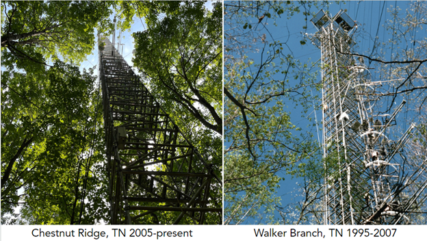
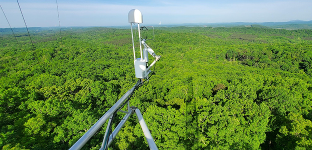
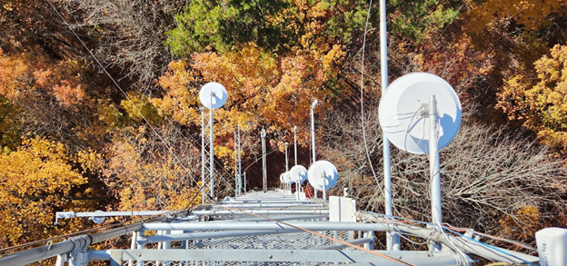
More than 40 years ago, ARL’s Atmospheric Turbulence and Dispersion Division began making measurements at a deciduous forest monitoring site in east Tennessee. These measurements were designed to better understand the flows of energy, carbon dioxide and water vapor between the forest and the lower atmosphere. The original measurement site was located on the property of Oak Ridge National Laboratory (ORNL) as part of a larger forest ecosystem study in the Walker Branch Watershed. In 1995, continuous measurements of energy budgets, carbon dioxide and water began at Walker Branch. In 2005, a second monitoring site, called Chestnut Ridge, was established a few miles away from the Walker Branch site (which was retired in 2007). Chestnut Ridge consists of a 60 meter walkup tower in a mixed deciduous forest and is  part of ARL’s Surface Energy Budget Network (SEBN). Measurements at Chestnut Ridge include above-canopy CO2 and water vapor fluxes; incoming and outgoing shortwave, longwave, and photosynthetically-active radiation; wind; pressure; surface temperature; precipitation; and soil temperature and moisture.

Chestnut Ridge Tower, carbon dioxide, methane and water vapor flux measurement devices mounted 100 ft above the canopy.

Due to its location, existing infrastructure, and extensive array of long-term measurements (in combination with data from Walker Branch), Chestnut Ridge is a unique and valuable research site. Over the years, the Air Resources Laboratory has collaborated with other NOAA laboratories, government agencies, and university partners, such as Vanderbilt University, San Diego State University, the University of Arizona, and Colorado State University, who have added additional instruments to the site for short- and long-term studies. These collaborations address mutually-beneficial science questions on atmospheric boundary layer processes, land-atmosphere interactions and atmospheric chemistry. Better knowledge in each of these areas informs improvements to atmospheric boundary layer processes and land surface parameterization schemes used in numerical weather prediction models, atmospheric chemistry models and climate models.

Looking down from the top of the Chestnut Ridge Tower. You can see wind, temperature and turbulence measurement devices mounted at varying heights.

The combined long-term record of measurements at Walker Branch and Chestnut Ridge provide a better understanding of how rising CO2 concentrations and increasing average temperatures affect the forest’s ability to sequester carbon into the forest ecosystem. The data shed light on how the forest responds to changing environmental conditions, in particular changes in the timing and length of the growing season and changes in precipitation and moisture. Additional instrumentation being installed at Chestnut Ridge will enhance the understanding of in-canopy physical and biological processes that affect the flows of energy, carbon, water and other trace species to and from the atmosphere. All of this data and new scientific understanding can be used to improve NOAA’s weather and air quality forecast models and validate long-term climate model predictions.